|
I left Durango and continued towards Mesa Verde/Cortez ...driving from memory, and looking for a sign any sign! I finally saw it, and was reminded that it was several miles into the actual facility from the entrance.  Read between the lines.. I need to fuel up! There happens to be a gas station at the park entrance...once again read between the lines...a bit more expensive, but convenience has its price! Read between the lines.. I need to fuel up! There happens to be a gas station at the park entrance...once again read between the lines...a bit more expensive, but convenience has its price!
The time was approaching 5:00 p.m. mountain time, and the park stores would be closing soon. I was told as I went in, that if I hurried, I would be able to make it to the visitors center before it closed. It is about 22 miles in, around and over the park road that leads to visitors center, which I made in time to walk thru and decide that I needed to go farther down the road to the dwellings. I made it in plenty of time to walk thru one of the main dwellings known as Spruce Tree House. I have developed an avid interest in these type of dwellings, and especially some of the pictographic areas that seem to be near most of them. There appears to be similarities in some of the 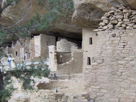 drawings and ancient Egyptian drawings. I have always wondered about a world-wide economy/travel system that might of existed far in advance of what we currently accept. Perhaps it existed, there is evidence to support it in the Americas. drawings and ancient Egyptian drawings. I have always wondered about a world-wide economy/travel system that might of existed far in advance of what we currently accept. Perhaps it existed, there is evidence to support it in the Americas.
Back to my travels! After walking the Spruce Tree house, which is open to the general public, I began my return to the parking area. In doing so, I passed a trailhead that indicated some drawings were within walking distance. As my luck would have it, the story gets interesting now! I stopped to read the sign that indicated the trip would be over 2 miles miles or 2 hours. It was 6:00 p.m. at this point. I had no intention of being out after dark. Further, there was a gate that was locked at 6:30 p.m. to prevent more people from entering the trails, but it also meant that once it was locked you were committed to finishing the trail.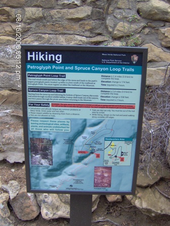 Now as I was reading this information, an older couple approached and during the course of chatting with them I gained the impression that they thought it could be done in less than an hour. Now at this point, I was thinking to my self...self, if they can do it in less than an hour, surely I can! Well, I signed in, and proceeded down the nice smooth path. I should have noticed they did not follow. About 10 minutes into the walk, the path really began to decay, and I should have turned around, but I was thinking, “if they can do it, I can do it.” At 30 minutes into this hike, I realized my phone didn’t work, I didn’t have any water, and I wasn’t even sure that I had a trail map. As luck would have it, I had stuffed one in my rear pocket. I happened to be by a sign post with a number “4” on it. After looking at the map, I determined that there were 35 or so markers......geez, I have a long ways to go!! I should also mention that the gate is locked behind me, and I was committed. Several foul thoughts went thru my mind and probably escaped my mouth at this point. I also noticed a buzzard roost above me, I thought it humerous... “hey, I am not dead yet!” Now as I was reading this information, an older couple approached and during the course of chatting with them I gained the impression that they thought it could be done in less than an hour. Now at this point, I was thinking to my self...self, if they can do it in less than an hour, surely I can! Well, I signed in, and proceeded down the nice smooth path. I should have noticed they did not follow. About 10 minutes into the walk, the path really began to decay, and I should have turned around, but I was thinking, “if they can do it, I can do it.” At 30 minutes into this hike, I realized my phone didn’t work, I didn’t have any water, and I wasn’t even sure that I had a trail map. As luck would have it, I had stuffed one in my rear pocket. I happened to be by a sign post with a number “4” on it. After looking at the map, I determined that there were 35 or so markers......geez, I have a long ways to go!! I should also mention that the gate is locked behind me, and I was committed. Several foul thoughts went thru my mind and probably escaped my mouth at this point. I also noticed a buzzard roost above me, I thought it humerous... “hey, I am not dead yet!”
I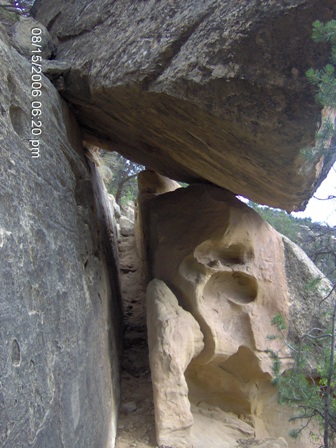 immediately took off and proceeded as fast as I could throught the trail. Which had lost its National Parks rating for Handicapped or perhaps even reasonably lazy people like me! I am sure that you might have noticed that I am not a small person, and there were a couple of times I thought I might need to go over instead of thru. But I made it! I became increasingly concerned as I progressed though. It was getting dark in the canyon, and I was really wanting a drink. “Stupid, Stupid, Stupid..”. I kept stopping to listen. This was a immediately took off and proceeded as fast as I could throught the trail. Which had lost its National Parks rating for Handicapped or perhaps even reasonably lazy people like me! I am sure that you might have noticed that I am not a small person, and there were a couple of times I thought I might need to go over instead of thru. But I made it! I became increasingly concerned as I progressed though. It was getting dark in the canyon, and I was really wanting a drink. “Stupid, Stupid, Stupid..”. I kept stopping to listen. This was a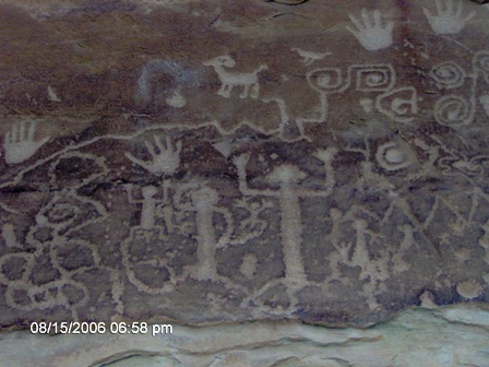 National Park, right? People everywhere.. . but not today! I had images in my mind of falling down one of the many steep steps or just slipping and breaking a leg or something! Finally, I made it, and it was worth the walk. But, the climb out was interesting.. and I had a ways to go. Thus far, I was 1 hour into this hike and I had been moving as fast as I could to get back to the bike. It was getting darker, and I wasn’t sure how National Park, right? People everywhere.. . but not today! I had images in my mind of falling down one of the many steep steps or just slipping and breaking a leg or something! Finally, I made it, and it was worth the walk. But, the climb out was interesting.. and I had a ways to go. Thus far, I was 1 hour into this hike and I had been moving as fast as I could to get back to the bike. It was getting darker, and I wasn’t sure how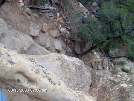 much longer I would be walking... As it turns out, the hike out was relatively flat and fast. I made it back in 20 minutes...extremely tired, but alive and ready to ride out! I couldn’t get to the sign out book, so I wondered if the park officials checked it and would be looking for people that left late and didn’t return.. hmm.. You know, as I wrote this, I checked the time stamps on the photos, and I made it back to the trailhead at 7:37... and actually started at 6:12...not bad for a 41 year old, overweight biker with no water. I did have a bad attitude... left the park rather fast, I was hungry and tired. I really wanted to just sleep. much longer I would be walking... As it turns out, the hike out was relatively flat and fast. I made it back in 20 minutes...extremely tired, but alive and ready to ride out! I couldn’t get to the sign out book, so I wondered if the park officials checked it and would be looking for people that left late and didn’t return.. hmm.. You know, as I wrote this, I checked the time stamps on the photos, and I made it back to the trailhead at 7:37... and actually started at 6:12...not bad for a 41 year old, overweight biker with no water. I did have a bad attitude... left the park rather fast, I was hungry and tired. I really wanted to just sleep. 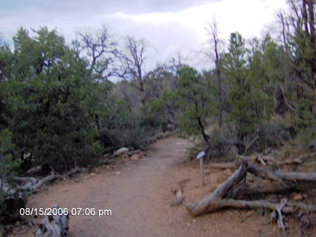 I found a hotel in Cortez, which I believe was a Comfort Inn. It has a covered parking area just for motorcycles. Thanks for being motorcycle friendly!!!! read more... I found a hotel in Cortez, which I believe was a Comfort Inn. It has a covered parking area just for motorcycles. Thanks for being motorcycle friendly!!!! read more...
|